
Aviation Weather Information Service
www.weatherweb.net
CHANNEL ISLANDS
This forecast is updated at 7am, 1pm and 7pm
Issued by Weather Consultancy Services on:
Wednesday 24 April 2024 18:00 hrs
Support: help@weatherweb.net Print this page

|
|
Aviation Weather Information Service www.weatherweb.net CHANNEL ISLANDS This forecast is updated at 7am, 1pm and 7pm
Issued by Weather Consultancy Services on: |
|
|
7 Day Look Ahead Forecast from GFS model for flying in the Channel Islands: Data based on GFS model updated: Wed 24 April 2024 18:00
|
|||||||||||||||
|
Planning outlook for the English Channel: The week will see a return to an unsettled spell with sunshine and frequent showers and often longer spells of rain for all areas as pressure falls acorss UK with centres of low pressure affecting east at first, depressions approaching form southwest mid-week onwards. Wednesday 24 AprilOvernight ground and air frost for Scotland and northern England will clear by mid-morning to give a dry sunny start for all temperatures 2C generally 5 to 7C mid-morning. Continuing dry and sunny for all during the remainder of the morning and continuing with sunshine into the afternoon. Becoming rather cloudy late morning and into the afternoon across Yorkshire through to Kent and Sussex with scattered showers running onto North Sea coasts. Cool for all temperatures 6 to 8C where cloud persists along coasts, 10-12C elsewhwere briefly 14C Somerset to Dorset. Winds generally light though fresher along North Sea coasts with windchill. Thursday 25 AprilGround and air frost to clear by mid-morning across Scotland to northern England. A cool though mainly dry day with sunshine and variable cloud for most, 6 to 8C across Scotland and northern England, 10C elsewhere by early afternoon. Remaining cloudy through the afternoon with scattered showers across SE Scotland, NW to NE England and later for SE England, temperature reaminig around 10C though briefly 12C for SW England. Ground and air frost overnight across Scotland and into northern England.Friday 26/04/2024 A cloudy start for most, outbreaks of rain through the morning across Antrim to Lancashire, most of Wales to midlands and later E.Anglia to Kent 6 to 8C for Scotland, northern England to midlands with limited sunshine. Devon through Wiltshire to Berkshire broken cloud briefly to 13C during the afternoon, along with coastal SW Scotland with sunshine. Showers continuing into the evening across SW, Central to NE England with longer spells of rain for east and se England overnight. Brocken cloud and clear skies for Scotland will give patch ground and air frost overnight.Saturday 27/04/2024A cloudy day for all, rain wil be prolonged and often heavy during the morning for Cornwall, Devon to Dorset, into Wales, Wlltshire moving into Cumbria during the afternoon, with sunshine and showers following into SW England, 10C where cloud and rain persists, briefly 12C for SW and S England during the afternoon with scattered showers. Sunshine and showers becoming widespread across remainder of England into and during the afternoon continuing into the evening, afternoon temperature to 14C for Humberside through to Cambridgeshire. Cloudy across Scotland though staying mainly dry except for scattered showers NE to Shetland during the afternoon. Remainig cloud with rain becoming prolonged and heavy through the evening and overnight moving into Borders at first, later extending to remainder.Sunday 28/04/2024 A cloudy day with a mix of sunshine and showers, often merging to give longer spells of heavy rain. Rain, heavy at first for Somerset, Avon Wiltshire to Glamorgan will persist through the morning easing to sunshine and showers through the afternoon with an increasing fresh SW wind, 10 to 12C. An area of prolonged and heavy rain across Antrim to Dumfries moving into Western Isles during the morning, 8 to 10C here with a fresh SE wind. Rain later transferring to Abderdeenshire during the afternoon. Elswhere a mix of sunshine and showers, showers often heavy and prolonged mainly towards western locations, less frequent towards eastern England, temperature 12 to 14C for Leicestershire, to Lincolnshire, through to Hampshre and Kent during the afternoon. Monday 29/04/2024Remaining unsettled with a mix of sunshine and frequent showers, showers most frequent from Devon to Hampshire, across Wales and midlands, to Cheshire north to Northumberland, later into SW Scotland, 10 to 12 generally locally 14C with broken cloud and increasing sunshine Yorkshire to Kent. Showers continuing though decreasing through the evening with a mainly dry night to follow.Channel coasts with a freshening Easterly wind.Tuesday 30/04/2024 A dry and sunny start for all, with sunshine and variable, though increasing from the west cloud during the morning, 13 to 15C early afternon. Cloud increasing into Cornwall to Hampshire, across Wales to SW Scotland with rain becoming prolonged and heavy during the afternoon and evening, being slow to clear across SW England.Wednesday 01/05/2024 Cloudy for most with prolonged often heavy outbreaks of rain from SW England to Western Scotland during the morning moving into Dorset to Kent through the afternoon being slow to clear by evening. Generally cool 11 to 13C with a fresh SW wind along Channel coasts. |
Today (12 hours)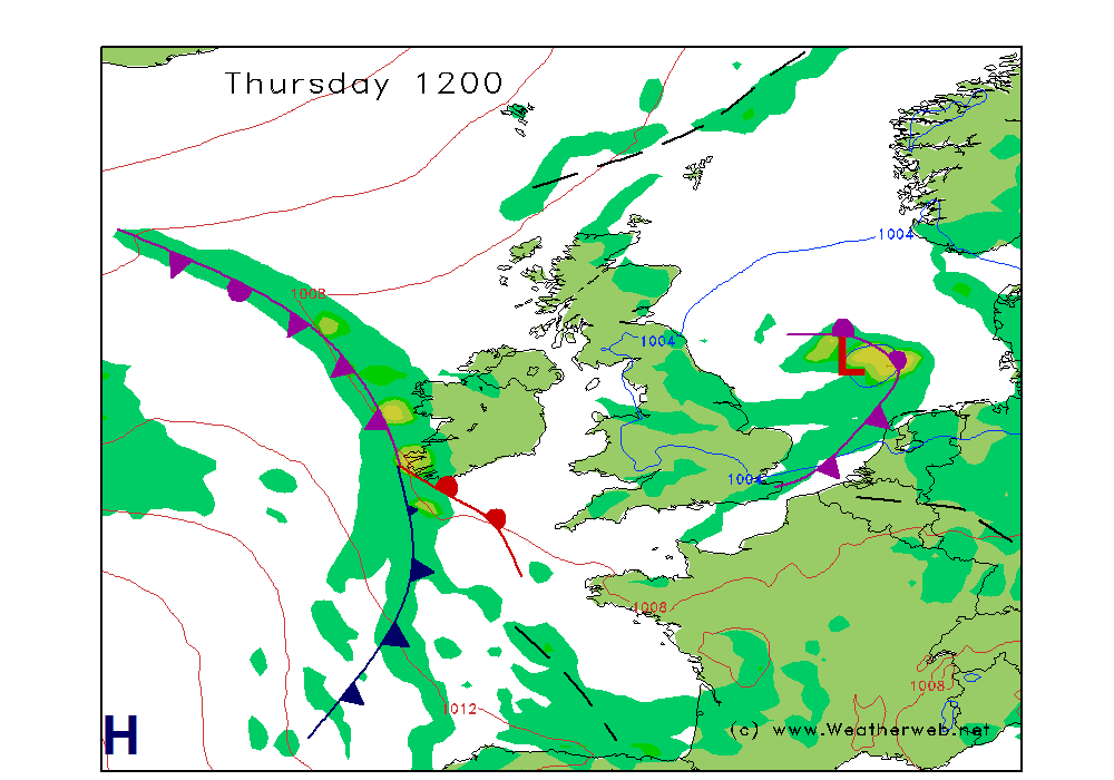 |
Tomorrow (36 hours |
| 60 hours |
84 hours |
| 108 hours |
120 hours |