Forecast for flying in East Scotland on Tuesday
Forecast will appear here.
|
Forecast from GFS model for flying in Moray, Aberdeen, SE Highland
Data based on GFS model updated: Tue 16 April 2024 03:00
| Time |
SFC Wind |
Sig wx * |
Visibility |
Temp |
QNH |
% low cloud |
Low cld base/top |
0C level |
RH@0C |
FL030 Wind |
Temp |
FL050 Wind |
Temp |
FL100 Wind |
Temp |
| 6am Tuesday | 140/4g22kt | Light rain | 24.1km | 7C | 1015mb | 100% | 1400/7100ft | 2000ft | 90% | 330/16kt | -1C | 210/7kt | -2C | 250/12kt | -6C | | 9am Tuesday | 150/4g21kt | * | 24.1km | 5C | 1015mb | 74.1% | 1900/6500ft | 2100ft | 80% | 330/14kt | -1C | 200/9kt | -2C | 260/12kt | -6C | | Midday Tuesday | 150/5g19kt | Light rain | 6.2km | 4C | 1015mb | 99.6% | 2500/7100ft | 2700ft | 60% | 310/15kt | 1C | 200/10kt | -2C | 230/9kt | -5C | | 3pm Tuesday | 160/6g23kt | * | 16.4km | 3C | 1013mb | 83.5% | 3900/9600ft | 2700ft | 70% | 300/19kt | 1C | 190/12kt | -2C | 210/14kt | -5C | | 6pm Tuesday | 160/6g24kt | Dry | 0.1km | 5C | 1013mb | 10.7% | 2800/9600ft | 1900ft | 70% | 310/18kt | -1C | 210/14kt | -1C | 220/18kt | -5C | | 9pm Tuesday | 170/8g29kt | * | 24.1km | 8C | 1012mb | 100% | 1900/9600ft | 1400ft | 90% | 290/25kt | -2C | 210/16kt | -1C | 220/20kt | -5C | | 00:01am Wednesday | 190/9g30kt | Dry | 19.9km | 10C | 1012mb | 94.5% | 1300/9200ft | 2000ft | 100% | 320/24kt | -1C | 200/16kt | 0C | 230/23kt | -5C | | 6am Wednesday | 190/8g16kt | Light rain | 0.1km | 11C | 1010mb | 9.6% | 1300/7700ft | 1900ft | 80% | 350/10kt | -2C | 210/17kt | 2C | 240/20kt | -4C | | Midday Wednesday | 170/7g10kt | Light rain | 13.4km | 7C | 1011mb | 79.6% | 2000/5700ft | 2400ft | 90% | 330/6kt | -0C | 230/18kt | 4C | 230/13kt | -4C | [* significant weather refers to weather in the past 6-hours, and is available in 6-hour steps only. All predictions are model estimated. Gusts are model predicted over open ground. Heights are above sea level.]
|
Planning outlook:
Tuesday low pressure and a cold front will move south across England and Wales with high pressure north west of Scotland. A colder day as rain and snow spreads south. Mainly dry in the channel with sunny spells. Visibilities will be good in the channel but moderate to poor elsewhere in rain and snow.
Wednesday a cell of high pressure is centered west of Ireland and will be ridging east. A cold, windy day with sunny spells and scattered showers of rain and snow. Visibilities will be good but moderate in rain showers, poor in snow showers.
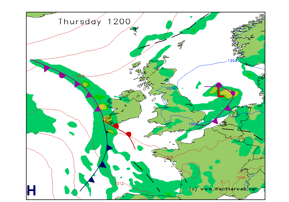
Thursday sees high pressure centred south of Ireland and this will give much of the country a dry, settled, day with sunny spells. Visibilities will be good.
Friday a cold front spreads rain down across Scotland, the Irish Sea and northern England. Fair and dry in the south and in the channel with varying cloud and sunny spells. Visibilities will be good in the south and in the channel, but falling to moderate or locally poor as the rain sets in across the north.
Saturday high pressure to the west of Britain is ridging into Scotland with a front into the far north west. Most areas will be fair and dry with sunny spells today after some patchy mist clears. Visibilities will be good but moderate at first.
Sunday a front moves south east across Britain. Outbreaks of rain will clear western areas in the afternoon. Visibilities will be moderate improving to good as the front clears.
|